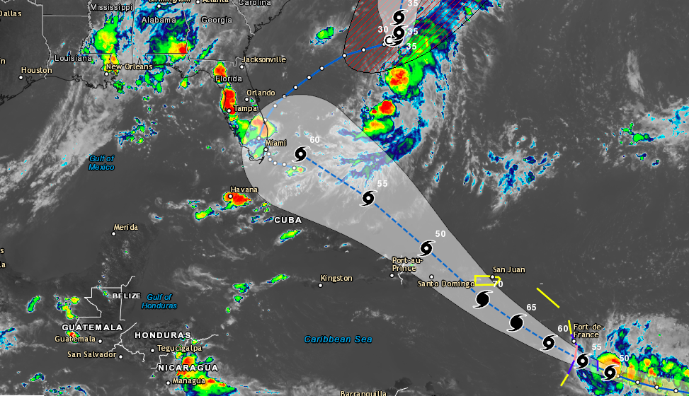
Tropical Storm Dorian has continued to strengthen over the past few days and currently has maximum sustained winds of 60 MPH. The storm is currently located about 60 miles southeast of Barbados and is moving northwest at 14 MPH. Tropical Storm conditions are expected in the Windward Islands later tonight with hurricane conditions possible on Tuesday.

A Hurricane Watch is in effect for St. Lucia.
A Tropical Storm Warning is in effect for:
* Barbados
* Martinique
* St. Lucia
* St. Vincent and the Grenadines

A Tropical Storm Watch is in effect for...
* Dominica
* Grenada and its dependencies
* Saba and St. Eustatius
* Puerto Rico

A Hurricane Watch means that hurricane conditions are possible within the watch area, in this case, within the next 24 hours.

A Tropical Storm Warning means that tropical storm conditions are expected somewhere within the warning area within 36 hours.

A Tropical Storm Watch means that tropical storm conditions are possible within the watch area, generally within 48 hours.

On the forecast track, the center of Dorian is expected to move near the Windward Islands this evening and tonight and move into the eastern Caribbean Sea on Tuesday. Dorian is forecast to pass near or south of Puerto Rico on Wednesday and approach eastern Hispaniola Wednesday night.

HAZARDS AFFECTING LAND
----------------------
Rainfall: Dorian is expected to produce total rain accumulations of 3 to 8 inches in the Windward Islands from Martinique south to St. Vincent, including Barbados.  Isolated maximum totals of 10 inches are possible across the northern Windward Islands.  Rainfall totals of 1 to 3 inches are expected from the Grenadines, south to Grenada and across Dominica.  Rainfall totals of 2 to 4 inches with maximum totals of 6 inches are possible across Puerto Rico and St. Croix.

WIND:  Hurricane conditions are possible tonight and early Tuesday within the Hurricane Watch area.  Tropical storm conditions are likely in the warning area by late today. Tropical storm conditions are possible within the tropical storm watch area in the Lesser Antilles tonight or Tuesday and in Puerto Rico on Wednesday.

SURF:  Swells generated by Dorian will begin affecting portions of the Lesser Antilles tonight and continue into Tuesday. These swells could cause life-threatening surf and rip current conditions. Please consult products from your local weather office.


Have you ever considered about adding a little bit more than just your articles? I mean, what you say is fundamental and all. However think about if you added some great images or video clips to give your posts more, “pop”! Your content is excellent but with images and clips, this site could undeniably be one of the most beneficial in its field. Great blog!
Thanks for the reply. We will take that into consideration. We do multiple posts for many storms, so the details and images/videos are usually split between multiple posts. Thanks for using SevereWXWarn.