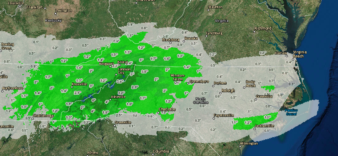
Snow is in the forecast for parts of North Carolina this Sunday and some areas could see up to 3 inches of snow depending on where you are in NC. We first broke news of this system about 2 weeks ago when we said that it was a possibility that the Carolina’s could see some snowfall in the coming weeks. This system decided to take a more southerly route so not all of North Carolina will get some and none of South Carolina will see accumulation, but the piedmont and mountains of North Carolina and much of north western Virginia will see some accumulation of snow. This accumulation will likely be to grassy surfaces and not roads so travel should be monitored any time there is winter precipitation, but should not be a problem east of the mountains. Below is a map of the amounts for North Carolina as well as the amounts by town/region. Please be sure to like us on Facebook to receive information on future severe weather and also be sure to download our Snowfall Forecast app on Android and Apple. Lastly you can use the buttons above to share this article with your friends and family on social media. As always thanks for making us your #1 source for weather. If you have any questions about this forecast feel free to message us via Facebook and we will do our best to respond accordingly.
Snowfall Amounts:
Northern NC Piedmont- Up to 1″
Southern NC Piedmont-Flurries with no accumulation
Most of the NC Mountains- Up to 1″
Eastern NC (Raleigh East) – Maybe a flurry or 2 with no accumulation
Madison, Yancey, Avery and Mitchell counties – 1-2″ with some areas receiving 2-3″


