Satellite and radar data indicate that the depression continues to
become better organized, but surface data suggests the circulation
may be somewhat elongated.  There is still evidence of westerly
shear as the center is located near the western edge of the main
convective mass, but there has been an increase in banding over
the eastern semicircle since yesterday afternoon.  The depression
appears to be close to tropical storm strength and Dvorak
estimates from TAFB and SAB are between 30-35 kt.  An Air Force
Reserve reconnaissance aircraft is scheduled to investigate the
system early this afternoon and should provide a better assessment
of the intensity of the cyclone.  For now, the intensity is held at
a possibly conservative 30 kt.

The moderate westerly shear that is affecting the depression is
forecast to gradually decrease over the next day or two as an
upper-level trough over the Gulf of Mexico moves westward and
weakens.  This, in combination with warm waters, should allow for
gradual strengthening as the system moves northward over the Gulf of
Mexico.  Nearly all of the intensity models bring the cyclone to
hurricane strength over the Gulf of Mexico in 2 to 3 days, and the
NHC forecast follows suit. The new NHC intensity forecast is
slightly higher than the previous advisory and again lies near the
ICON intensity consensus. This is a little below the more aggressive
HWRF and HCCA models.

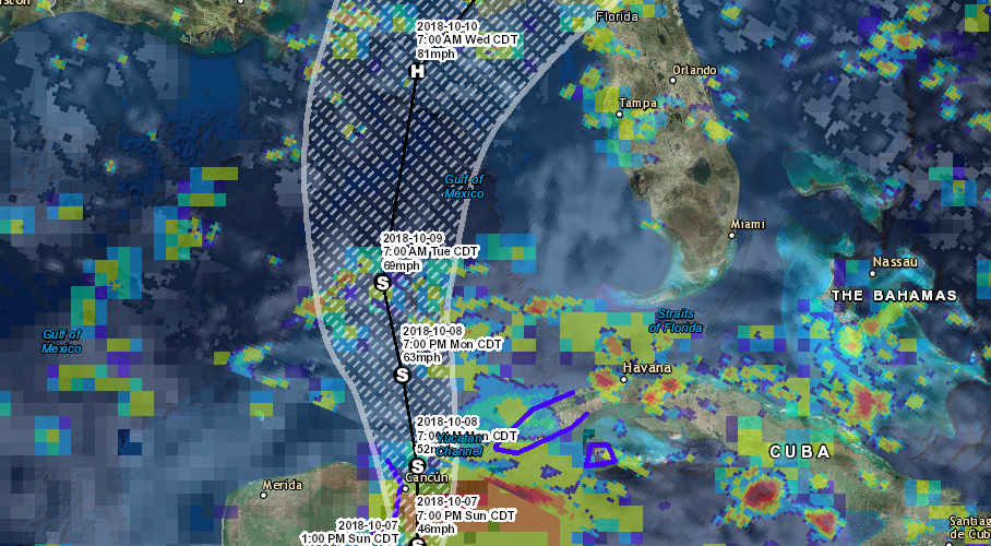
The depression is moving northward at about 5 kt.  The system is
forecast to move generally northward during the next 2 to 3 days,
with some increase in forward speed as it moves between a deep-layer
ridge over the western Atlantic and a trough over the west-central
United Sates.  A northeastward turn is expected after 72 hours as
the aforementioned trough progresses eastward across the central
United States.  The dynamical models generally agree on the overall
scenario, but there are still large difference in forward speed. In
fact, the ECMWF ensemble has members that are still over the Gulf of
Mexico in 5 days, and others that reach southern New England in that
time period.  The NHC forecast is near the left side of the guidance
envelope through 48 hours out of respect for the GFS and ECMWF that
are both on that side of the track spread.  After that time, the NHC
track forecast is close to the various consensus aids to account for
both the along and cross track spread of the guidance.


Key Messages for Tropical Depression Fourteen:

1.  The depression is forecast to produce heavy rainfall and
flash flooding over portions of western Cuba and the northeastern
Yucatan Peninsula of Mexico during the next couple of days.

2.  The depression is forecast to become a tropical storm later
today, and tropical storm conditions are expected by tonight over
portions of western Cuba and the northeastern Yucatan Peninsula,
where tropical storm warnings are in effect.

3.  There is an increasing risk of dangerous storm surge, rainfall,
and wind impacts over portions of the northern Gulf Coast by
mid-week, although it is too soon to specify the exact location and
magnitude of these impacts.  Residents in these areas should monitor
the progress of this system.


FORECAST POSITIONS AND MAX WINDS

INIT  07/1500Z 19.2N  86.9W   30 KT  35 MPH
 12H  08/0000Z 20.0N  86.5W   40 KT  45 MPH
 24H  08/1200Z 21.5N  86.5W   45 KT  50 MPH
 36H  09/0000Z 23.2N  86.8W   55 KT  65 MPH
 48H  09/1200Z 24.9N  87.2W   60 KT  70 MPH
 72H  10/1200Z 28.7N  86.5W   70 KT  80 MPH
 96H  11/1200Z 33.0N  82.5W   45 KT  50 MPH...INLAND
120H  12/1200Z 37.8N  73.0W   45 KT  50 MPH...POST-TROP/EXTRATROP

Courtesy: National Hurricane Center


